Search
Now showing items 1-10 of 10
Several Tsunami Scenarios at the North Sea and their consequences at the German Bight
(Journal of Tsunami Society International vol.32 no.1 2013, 2013)
Tsunamis occurred in the past at the North Sea, but not frequently. There are historical and geological records of several tsunamis: the Storegga tsunami caused sediment deposits in Scotland 8,000 years ago and records of ...
Evaluación de la peligrosidad del tsunami de Chile del 16 de setiembre del 2015 para Costa Rica
(Revista Ciencias Marinas y Costeras vo.8 no.1 113-128 2016, 2016)
A Mw 8.3 earthquake took place in Chile on September 16th, 2015 causing a local tsunami. As a consequence, this earthquake prompted the National Tsunami Monitoring System (SINAMOT) in Costa Rica to conduct a tsunami hazard ...
Sistema Nacional de Monitoreo de Tsunamis
(Revista Universidad en Diálogo vol.5 no.2 101-111 2015, 2015)
En cualquier cuerpo de agua, y más específicamente en cualquier océano, se pude generar un tsunami. Por esto, nuestro país, al tener dos costas, se encuentra expuesto a ellos. Los tsunamis no se pueden evitar ni pronosticar ...
Importancia de la batimetría de las planicies abisales en la propagación de tsunamis transoceánicos
(Ciencia y tecnología Vol.25,No.1-2 22-33, 2007)
The initial form of a tsunami originated by an homogeneous seismic source consists on a simple wave front. While the tsunami propagates in deep water, this simple form suffers several modifications ...
Modeling a tsunami from the Nicoya, Costa Rica, seismic gap and its potential impact in Puntarenas
(Journal of South American Earth Sciences .Vol.31 No.4 372-382, 2011)
Although subduction zones around the world are known to be the source of earthquakes and/or tsunamis, not all segments of these plate boundaries generate destructive earthquakes and catastrophic tsunamis. Costa Rica, in ...
Factores que influyen en la forma de la cola de un tsunami
(UNICIENCIA Vol. 23 65-69, 2009)
The propagation speed of a tsunami depends on the depth of the ocean in which it propagates. As the tsunami crosses the abyssal plain, it suffers modifications in its form due to change in the depths of the ocean bottom. ...
A Collaborative Effort Between Caribbean States for Tsunami Numerical Modeling: Case Study CaribeWave15
(Pure and Applied Geophysics vol.175 no.2 1405-1428 2017, 2017)
Historical records have shown that tsunami have affected the Caribbean region in the past. However infrequent, recent studies have demonstrated that they pose a latent hazard for countries within this basin. The Hazard ...
Numerical Simulations of the 1991 Limón Tsunami, Costa Rica Caribbean Coast
(Pure and Applied Geophysics vol.174 2945-2959 2017, 2017)
The second largest recorded tsunami along the Caribbean margin of Central America occurred 25 years ago. On April 22nd, 1991, an earthquake with magnitude Mw 7.6 ruptured along the thrust faults that form the North Panama ...
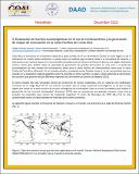
Evaluación de fuentes tsunamigénicas en el sur de Centroamérica y la generación de mapas de evacuación en la costa Pacífica de Costa Rica
(Geo - Network of Latinomerican - German alumi (GOAL) 7-10 2015, 2015)
Costa Rica se encuentra en el extremo oeste de la placa Caribe, en el sur de América Central. En esta región se da la interacción de cuatro placas tectónicas. La placa Cocos se subduce bajo la placa Caribe y la microplaca ...
Metodología para la Evaluación de Rutas de Evacuación en caso de Tsunami Aplicado a la Costa del Pacífico Norte y Central de Costa Rica
(Revista en Torno a la Prevención no.16 17-26 2016, 2016)
Se ha diseñado un método con el objetivo de elaborar una cartografía de rutas de evacuación en caso de tsunami a escala 1:10.000, basado en las directrices establecidas por la Comisión Europea. Las áreas de estudio son las ...