Browsing by Subject "EARTHQUAKES"
Now showing items 21-32 of 32
-
Repeating earthquakes record fault weakening and healing in areas of megathrust postseismic slip
(American Association for the Advancement of Sciences (AAAS), 2020)Repeating earthquakes (REs) rupture the same fault patches at different times allowing temporal variations in the mechanical behavior of specific areas of the fault to be interrogated over the earthquake cycle. We study ... -
Seismic activity at Irazú volcano after the 5th September 2012 Nicoya, Earthquake, Costa Rica
(2013)Póster sobre actividad sísmica en el volcán Irazú después del terremoto del 5 de septiembre de 2012 en Nicoya, Costa Rica -
Seismogenic zone structure beneath the Nicoya Peninsula, Costa Rica, from three-dimensional local earthquake P- and S-wave tomography
(Geophysical Journal International, 2006)The subduction plate interface along the Nicoya Peninsula, Costa Rica, generates damaging large (Mw > 7.5) earthquakes. We present hypocenters and 3-D seismic velocity models (VP and VP/VS) calculated using simultaneous ... -
Sismo de Capellades 01 diciembre 2016, Cartago, Costa Rica
(REVISTA GEOGRÁFICA DE AMÉRICA CENTRAL, 2018)En este trabajo se hace una descripción de la fuente sísmica del sismo de Capellades, provincia de Cartago, Costa Rica, del 1 de diciembre de 2016, 00:25:20 hora UTC. Se estudian los parámetros de la fuente, centroide, ... -
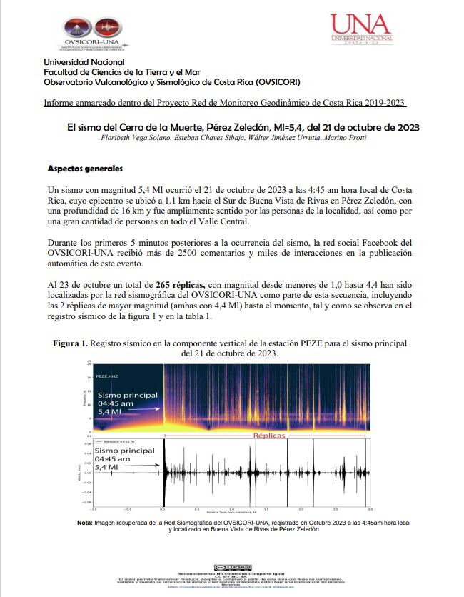
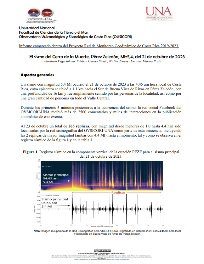
El sismo del Cerro de la Muerte, Pérez Zeledón, Ml=5,4, del 21 de octubre de 2023
(Universidad Nacional, Costa Rica, 2023)Un sismo con magnitud 5,4 Ml ocurrió el 21 de octubre de 2023 a las 4:45 am hora local de Costa Rica, cuyo epicentro se ubicó a 1.1 km hacia el Sur de Buena Vista de Rivas en Pérez Zeledón, con una profundidad de 16 ... -
El sismo del Cerro de la Muerte, Pérez Zeledón, Ml=5,4, del 21 de octubre de 2023
(Universidad Nacional, Costa Rica, 2023)Informe enmarcado dentro del Proyecto Red de Monitoreo Geodinámico de Costa Rica 2019-2023 -
Sistema Web para el reporte y graficación de un mapa de intensidades sísmicas de los distritos de Costa Rica, a partir de la información brindada por la población, elaborado para el OVSICORI
(Universidad Nacional (Costa Rica), 2010-11)El proyecto desarrollado es un Sistema Web, que genera una representación gráfica de un mapa de intensidades, es decir, que establece de forma gráfica cuan fuerte se el sismo en las diferentes localidades de Costa Rica. Un ... -
The intraplate Porto dos Gaúchos seismic zone in the Amazon craton — Brazil
(Elsevier, 2009-01-15)The largest earthquake observed in the stable continental interior of the South American plate occurred in Serra do Tombador, Mato Grosso state — Brazil, on January 31, 1955 with a magnitude of 6.2 mb. Since then no other ... -
The March 25, 1990 (Mw=7.0, ML=6.8), earthquake at the entrance of the Nicoya Gulf, Costa Rica: Its prior activity, foreshocks, aftershocks, and triggered seismicity
(American Geophysical Union, 1995-10-10)On March 25, 1990 a large earthquake (Mw = 7.0, ML = 6.8) occurred at the entrance of the Nicoya Gulf, Costa Rica, at 1322:55.6 UTC, producing considerable damage in central Costa Rica and generating much interest about ... -
The Mw 6.4 Damas, Costa Rica, Earthquake of 20 November 2004: Aftershocks and Slip Distribution
(Seismological Society of America, 2006-08)The earthquake of 20 November 2004 was located north of Damas Island in the Pacific coast of Costa Rica, within the Costa Rica Deformed Belt. The earthquake was located at 24 km depth and reported with a magnitude (Mw) of ... -
Tomographic evidence for a subducted seamount beneath the Gulf of Nicoya, Costa Rica: The cause of the 1990 Mw = 7.0 Gulf of Nicoya earthquake
(American Geophysical Union, 2002-04-26)Tomographic images constrain the existence of a subducted seamount beneath the Gulf of Nicoya, Costa Rica. The subducted seamount is found at a depth of 30 km within the rupture area of the March 25, 1990, Mw = 7.0 Gulf ... -
Zonificación de la amenaza por deslizamientos del sector noroeste del Volcán Poás, a partir de evaluación sísmica y geomorfológica
(Universidad Nacional, Costa Rica, 2019)Determina una zonificación de deslizamientos de acuerdo con datos sísmicos y técnicas geomorfológicas en el sector noroeste del volcán Poás, basado en una integración de la modificación del método Mora-Vahrson-Mora y la ...